
|
|||
|
|
|||
|
|
||||||||
|
Explore the topography of the Bryant Creek watershed The Bryant watershed has its own unique surface features:
its topography. Its hills and valleys result from the effect of running
water cutting through the various kinds of rock that make up the bedrock
beneath its soils. |
||||||||
|
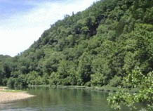
It is the central core of the watershed that makes the watershed special. That's where you find the valleys of Bryant Creek and its larger tributary streams. Their steep rock walls (bluffs) are notable features of the Bryant and its sister stream, the North Fork.
|
|
|||||||


 The
gentle and steeply rolling hills and valleys around the edge of the watershed
are like most of the Ozarks of southern Missouri. They are at a higher
elevation than the center of the watershed.
The
gentle and steeply rolling hills and valleys around the edge of the watershed
are like most of the Ozarks of southern Missouri. They are at a higher
elevation than the center of the watershed.
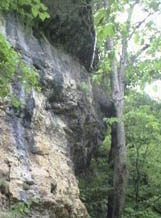 The bluffs and deep steep-walled valleys have resulted from streams eroding
through a hard layer of
The bluffs and deep steep-walled valleys have resulted from streams eroding
through a hard layer of