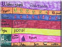
These graphs were produced by Barbara Groover's 5th grade at Ava Middle School in Fall 2001, as an extension of the Watersheds Everywhere lesson plan.
Click to see the graphs.
Subject Area: Social Studies, Geography Grade: 5 (can be adapted for Grades 4-8)
Curriculum Guide:Geography Locations, characteristics of places and relationships among people and their physical and social environments.
Goals/Standards: SS-5-5-1: Recognize the geographic themes and how they relate to the changes in society and the environment. SS-5-7-1: Use the tools of social studies inquiry.
Classroom Procedure
Watersheds Everywhere takes students through a variety of paper and online maps to explore the concept of watershed. It culminates with each student locating their own residence and identifying their own watershed addresses. Ms. Groover's students used Douglas County maps to find where they lived, and then located their particular watershed through the Local Watersheds map. Working in groups, they used that information to plot a variety of graphs and charts, showing how many students in their class lived in each of the local watersheds inside their school district.
Classroom Discussion Question
Why do you think people chose to live where they do?
The answers these students gave were varied, and included availability of services as well as proximity of family and close relatives.
Evaluation
Students learned their own watershed addresses, located those watersheds on a map, and discussed the social implications of living where they do.