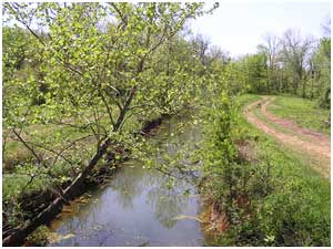
Galloway
Creek is about 2 miles northwest of downtown West Plains. The 5.3-mile
long tributary stream flows southeast and runs parallel to Holiday Lane
and the railroad tracks. [watershed map] [park
map]
Galloway Creek Nature Park
40-acres of Galloway Creek property was purchased by the
City of West Plains in 1982 with the understanding that the land would
be developed into a recreation park.
The project includes the development of a nature and interpretive
park that will be operated and maintained by various groups, including
civic organizations, local Boy and Girl Scout troops, environmental interest
groups, and the West Plains Parks and Recreation Department. Galloway
Creek Nature Park will be one of very few nature/interpretive parks of
this size in the South Central Ozarks region in southern Missouri.
Renovation activities underway include converting an existing
barn into a community interpretive center. The interpretive center will
feature natural, historical and cultural aspects of the project site,
including Native American artifacts that have been found on or near the
project site through the years. Development
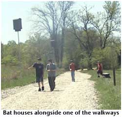
activities include construction of connecting pathways from the parking
area to areas along Galloway Creek and to interpretive areas of the park,
foot bridges over the creek, and a picnic pavilion that will double as
an outdoor classroom.
Galloway Creek Nature Park will include a 50 foot wooded
riparian buffer zone along each side of the creek; 25 foot buffer zones
along identified feeder streams west of the main creek bed, and a high
water channel 25 foot wide buffer zone. Wildlife
areas will be incorporated in the 40 acre park, as will perimeter buffer
zones, in order to help filter and perhaps reduce pollution from adjoining
properties entering the Galloway Creek property. The property will also
serve as a "green area" or corridor for wildlife communities.
Once the interpretive areas and connecting pathways are
completed it is envisioned that the local schools will use the park for
study, observation, and natural and native plant renovation and re-establishment.
The pavilion will also be available for local company picnics, school
class and family reunions and other groups wanting to gather for different
occasions.
The Missouri State University–West Plains Biology Department
has been working with MODOC and MODNR officials to inventory existing
stream conditions to establish baseline data for measuring water quality
and conditions. These same officials have also identified potential wetland
areas so that the design and construction of connecting pathways will
allow the public to view those areas with minimal impact to the site's
ecology.
One
of the main purposes of this project is to protect Galloway Creek from
further deterioration as a result of continuing urban development near
and adjacent to the project site. Local stream teams, biology students
from Missouri State University–West Plains, and other local community
groups have demonstrated their concern and willingness to help preserve
the natural elements of the site. In the future, it is hoped that further
land acquisition on both the north and south boundaries of the 40 acre
property will add to the overall nature park experience by making available
to the public more hardwood forest and a natural sinkhole representing
a good example of karst topography.
For more information on karst and sinkholes in West Plains and Galloway
Creek,
see Sinkholes Upstream From City
in Part 2 of Karst in the Watershed.
Adapted
from the grant application written by South Central Ozark Council of Governments.
The funding source for the development of Galloway Creek Nature Park is
the U.S. Department of Interior, National Park Service, Land and Water
Conservation Fund (LWCF). The LWCF program in Missouri is administered
by the Missouri Department of Natural Resources, Division of Parks and
Historic Preservation.
This is the Web site of the Bryant Watershed
Education Project, based in West Plains, Missouri. Our site is a toolkit
for exploring the Bryant Creek, North Fork, Eleven Point and Upper
Spring watersheds in the southern Missouri Ozarks. Learn more.


 Galloway
Creek is about 2 miles northwest of downtown West Plains. The 5.3-mile
long tributary stream flows southeast and runs parallel to Holiday Lane
and the railroad tracks.
Galloway
Creek is about 2 miles northwest of downtown West Plains. The 5.3-mile
long tributary stream flows southeast and runs parallel to Holiday Lane
and the railroad tracks.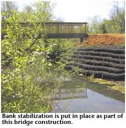 Development
activities include construction of connecting pathways from the parking
area to areas along Galloway Creek and to interpretive areas of the park,
foot bridges over the creek, and a picnic pavilion that will double as
an outdoor classroom.
Development
activities include construction of connecting pathways from the parking
area to areas along Galloway Creek and to interpretive areas of the park,
foot bridges over the creek, and a picnic pavilion that will double as
an outdoor classroom.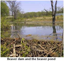 Wildlife
areas will be incorporated in the 40 acre park, as will perimeter buffer
zones, in order to help filter and perhaps reduce pollution from adjoining
properties entering the Galloway Creek property. The property will also
serve as a "green area" or corridor for wildlife communities.
Wildlife
areas will be incorporated in the 40 acre park, as will perimeter buffer
zones, in order to help filter and perhaps reduce pollution from adjoining
properties entering the Galloway Creek property. The property will also
serve as a "green area" or corridor for wildlife communities.
 One
of the main purposes of this project is to protect Galloway Creek from
further deterioration as a result of continuing urban development near
and adjacent to the project site. Local stream teams, biology students
from Missouri State University–West Plains, and other local community
groups have demonstrated their concern and willingness to help preserve
the natural elements of the site. In the future, it is hoped that further
land acquisition on both the north and south boundaries of the 40 acre
property will add to the overall nature park experience by making available
to the public more hardwood forest and a natural sinkhole representing
a good example of karst topography.
One
of the main purposes of this project is to protect Galloway Creek from
further deterioration as a result of continuing urban development near
and adjacent to the project site. Local stream teams, biology students
from Missouri State University–West Plains, and other local community
groups have demonstrated their concern and willingness to help preserve
the natural elements of the site. In the future, it is hoped that further
land acquisition on both the north and south boundaries of the 40 acre
property will add to the overall nature park experience by making available
to the public more hardwood forest and a natural sinkhole representing
a good example of karst topography.  Adapted
from the grant application written by South Central Ozark Council of Governments.
The funding source for the development of Galloway Creek Nature Park is
the U.S. Department of Interior, National Park Service, Land and Water
Conservation Fund (LWCF). The LWCF program in Missouri is administered
by the Missouri Department of Natural Resources, Division of Parks and
Historic Preservation.
Adapted
from the grant application written by South Central Ozark Council of Governments.
The funding source for the development of Galloway Creek Nature Park is
the U.S. Department of Interior, National Park Service, Land and Water
Conservation Fund (LWCF). The LWCF program in Missouri is administered
by the Missouri Department of Natural Resources, Division of Parks and
Historic Preservation.