|
 
Watersheds
 Bryant Creek Tributaries
  Brush Creek
 Brush Creek
 Location Location
The Brush Creek watershed lies 15 miles south of Mountain Grove. Rainwater
falling on the watershed runs from the Highway 95 Ridge to the east; to
the west and south from Highway W; to the north from Highway 14; and to
the west of a high ridge.
Watershed Size: About 45 square miles.
Shannon Ranch Conservation
Area contains 1,325 acres of public land. About half of the ranch
is in the Brush Creek watershed. The headwaters of the West Fork of Brush
Creek flow from Shannon Ranch. It includes forestland, pastureland and
glades. Hunting and primitive camping are allowed. It's located one and
a quarter miles south of Vanzant on Highway 95.
Communities
Buckhart is on the West Fork of Brush Creek, at the end of Highway CC.
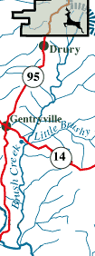
Gentryville and Drury are on Highway 95, the western boundary.
Roads: Highway 14 crosses the Brush Creek watershed near the
southern end. There are many county gravel roads in the watershed. You
can drive along Brush Creek and its tributaries on county gravel for
several miles. A county road runs along the creek for 5 miles from Buckhart
to the Highway 14 bridge. Roads run for 2 miles north of Buckhart, and
for 2 miles along Little Brush Creek.
 Topography Topography
Elevation ranges from 1,300 feet above sea level at Campbell Hill east
of Buckhart to 700 feet at its mouth. Maximum relief is 600 feet.
Stream Flow
Brush Creek is perennial from its mouth to Buckhart, about 7 miles.
It flows intermittently for 3 miles beyond that in each of its 2 forks.
Bryant Flow Contributor Rank
Brush Creek is the third largest tributary of the Bryant.
Tributaries
Little Brushy Creek is a perennial stream for about 3 of its 5 miles.
Pedro Hollow flows perennially for 2 of its 3 miles. Polepen Hollow
is perennial for about a mile. It has several springs in its valley.
Landscape & Special Features
Much of the watershed has moderately steep slopes. Much of the wide
creek bottom and nearby lower slopes have been cleared for pasture.
Bottoms and slopes of the tributaries are also pasture. Many of the
broad ridges throughout the watershed are pasture land. Much forest
remains on the steeper slopes of the upper watershed and in steep patches
in the middle and lower watershed.
Topographic Maps: Gentryville and Vanzant.
School Districts: Dora and Mountain Grove.

|

