watersheds.org the world in your watershed search
homeOnline Casinowhat's newabout ussite mapcontact us
 

Earth Hydrology Groundwater

Groundwater

student drawing Artwork by a local elementary student as part of a groundwater protection community program. more student work 
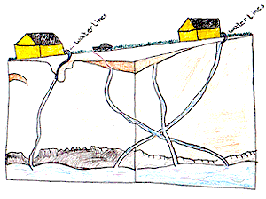
Groundwater is water underground in saturated zones beneath the land surface.
It fills the pores and fractures in underground materials such as sand, gravel, and other rock. 

If groundwater flows from rock materials or can be removed by pumping from the saturated rock materials in useful amounts, the rock materials are called aquifers. Groundwater moves slowly in an aquifer. As a result, water could remain in an aquifer for hundreds or thousands of years. 

Groundwater is the source of about 40% of water used for public supplies and about 38% of water used for agriculture in the United States.


Definitions

Water Table: The top of the water surface in the saturated zone of an aquifer. 

Infiltration: Movement of water from the land surface into the soil. 

Saturated Zone: Zone below the land surface where all the pores or fractures are filled with water. 

Unsaturated Zone: The zone immediately below the land surface where the pores or fractures contain both air and water.

Permeability: The capacity of porous rock for transmitting water. 

Groundwater Discharge: The flow or pumping of water from an aquifer. 

Groundwater Recharge: The addition of water to an aquifer. 

Groundwater and Karst

Karst topography is a landscape created by groundwater dissolving sedimentary rock such as limestone. To learn more about karst topography in the Ozarks and how it affects underground water movement in the region, see the Karst section.

Bryant Creek is called a "losing stream" because it loses part of its flow underground. In fact, the whole stream goes underground for about four miles near Dry Creek in the upper part of the watershed. It resumes surface flow near the mouth of Tarbutton Creek. Losing streams are typical of the karst topography found in the Ozarks.

The hydrologic relationship between Bryant Creek and the North Fork River, to which it is a tributary, is an unusually clear example of karst topography in action. The drainage areas, geology and climate are virtually identical. The Bryant drains 533 square miles, the North Fork drainage basin is 561 square miles. Therefore, one would expect the two streams to have similar flows. But the North Fork carries considerably more water! This is because water is being transported underground from the Bryant Creek watershed into the North Fork watershed. 


Sources: US Geological Survey, Environmental and Hydrologic Setting of the Ozark Plateaus Study Unit, Arkansas, Kansas, Missouri and Oklahoma,USGS 1995. Structural Controls on Streamflow in the North Fork River and Bryant Creek Basins, Missouri, US Geological Survey Professional Paper 600-C. 1968. Missouri Springs Virtual Resurgence
Written for the Atlas by Hank Dorst.

Top