|  
Outdoors  Public River Access Points Public River Access Points | Public River Access Points | 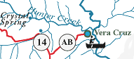 | Vera Cruz Picnic area. Fishing, hunting, primitive camping. Six miles east of Ava on Highway 14, then three miles north on Highway AB. | | | 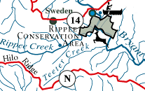 | Rippee Conservation Area River access. Fishing, hunting, primitive camping. Eleven miles east of Ava on Highway 14, then one and a half miles south on County Road 328. | | | 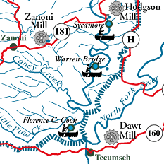 | Sycamore Access Twelve miles northeast of Gainesville on Highway 181. Warren Bridge Access Eight miles north of Tecumseh on Highway PP, then two and a half miles west on County Road 328. Florence C. Cook Access Three and a half miles east of Gainesville on Highway 160, then three miles north on County Road 308. |  watershed boundary watershed boundary | | See a full-size map of the watershed
|